The acceleration of the loss of the extent of the ice is mostly because the ice has been so thin. This would explain why it has melted so much this year. By June the ice edge had pulled back to where it normally is in September... .
..The 2007 record was set when you had weather conditions which were perfect for melting. This year we didn't have those. It was mixed. So this suggests the ice has got to a point where it's so thin it doesn't matter what the weather is, it's going to melt in the summer. This could become the new normal.Julienne Stroeve.
I've been one of what has seemed at times like a minority of one in the amateur community following the loss of Arctic sea ice. My view had been that the ice was transitioning to a new pseudo-equilibrium state, one with an ice pack composed almost entirely of young ice. I now doubt that such a pseudo-equilibrium state exists, and I anticipate a rapid transition by 2020 to a virtually sea ice free state (NSIDC Extent <1M km^2), I suspect it could be much earlier than that.
The loss of volume until recently has come from thicker ice categories, as thickness is a proxy for age it can be presumed that a process has been underway removing the thick old ice from the Arctic.
Indications are that this process is now at an end.
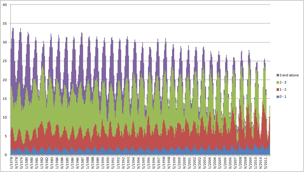
PIOMAS volume contributions from four thickness categories of sea ice, 1978 to 2011.
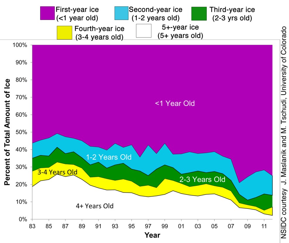
This is also supported by the work of Maslanik, which shows that ice over 4 years old is imminently due to be lost from the Arctic.
I had expected that at the end of the process of removal of old sea ice a new pseudo-equilibrium would begin with a younger ice pack more prone to melting ushering in a new regime of greater volatility. Since 2010, and certainly with this year, that seems to be what has happened. However I am no longer convinced that this is a semi-stable state that implies survival of the pack in summer until well into next decade.
The PIOMAS model is the best measure of volume we have, it is well verified against past observations such as submarine and satellite measurements. Furthermore initial indications are that Cryosat 2, the new satellite system supports PIOMAS, more here. And PIOMAS shows substantial recent March volume losses, implying thickness loss.
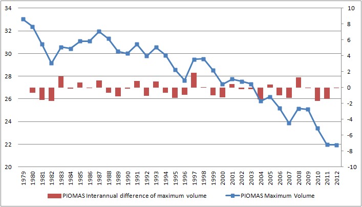
This is supported by the PSC's own calculation of thickness, here, and by calculated thickness, here. It's worth noting that there have been similar volume losses in the past, so what is different now?
The difference is that the ice is thinner.
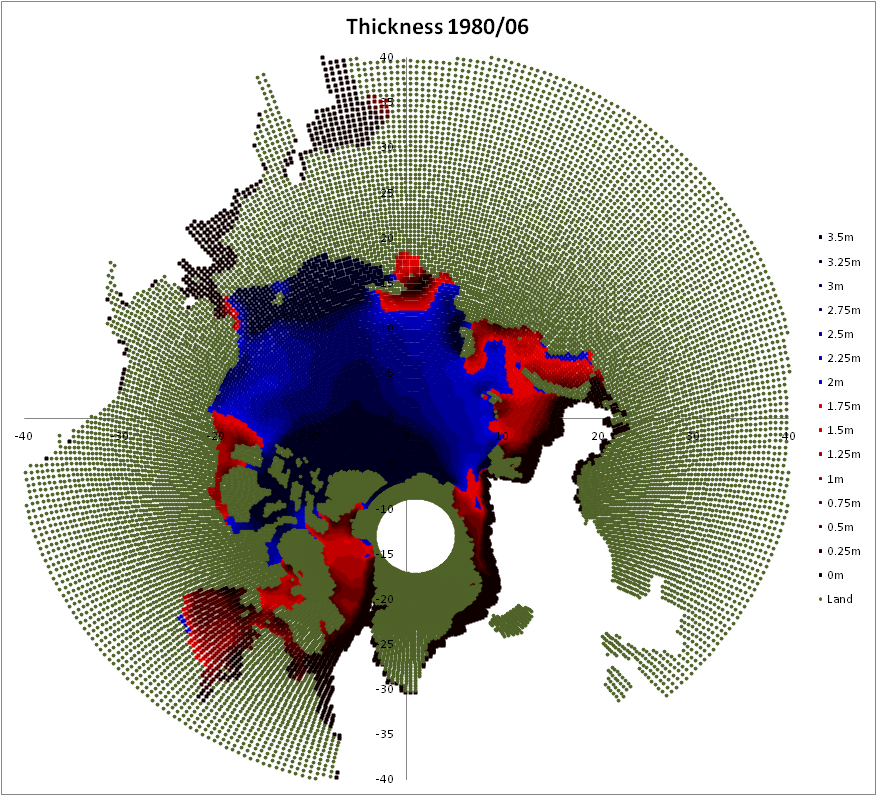
Here is the thickness* before the volume losses of 1981/2, a volume loss that didn't lead to a crash in area/extent. I've chosen June as this is at the beginning of the melt season before the biggest volume loss which is in July. *(PIOMAS gridded data - my presentation)
Here is the thickness before the volume losses of 2010/11.
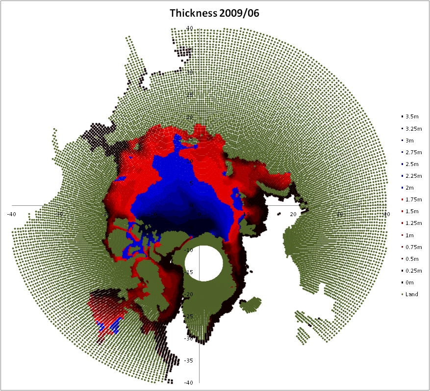
And here is the thickness in June of 2011, 2012 gridded data should be out sometime next year.

The following two graphics are taken from this presentation (pdf) by Marika Holland on Rapid Ice Loss Events (RILEs). I mentioned March ice volume in connection with my first graphic, that was not without reason; Holland's work shows that in models March thickness (therefore volume) drops during RILEs.
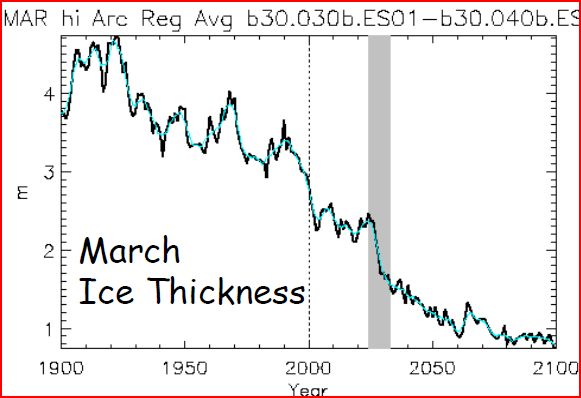
The RILE is marked with the grey band, it's worth noting that current thicknesses are below that of the model above during a RILE. Why is this important? After all as can be seen from the above two graphics, both volume and thickness show large drops earlier in the 20th Century. The key issue is Open Water Formation Efficiency (OWFE).
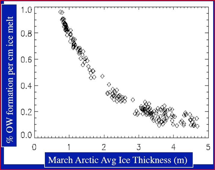
OWFE is defined as the percentage of open water made by each cm of vertical ice melt. Back in the 20th century and before the ice was thicker, so OWFE was low (to the right of that curve). But now the ice is much thinner so the same losses of thickness during the melt season are much more able to expose open ocean.
Going back to the presentation by Holland she states:
• In most extreme case, conditions go from near-present day
to near-ice free Septembers in ~10 yrs• The transitions result from:
– A vulnerable, thin ice state: Increased OW per melt rate
– A trigger: Increased OHT (natural variability?)
– Accelerating feedbacks: Albedo change/OHT?/Clouds?
As I've shown recently the loss of volume in 2010 rivals that of 2007, here, and was driven by unique weather conditions, here. 2007 was also driven by weather, but as it turns out the weather pattern responsible, the Arctic Dipole (AD) has stuck since then due to a highly anomalous atmospheric condition, here, why remains unclear. But the Arctic Dipole is a key player that transports warm air into the Arctic basin, has a proven role in sea ice loss (here), and has been active every year since 2007 in early summer, as Overland et al show (see previous post for reference).

The June AD index from 1950 to 2012 shows how unusual recent years have been.
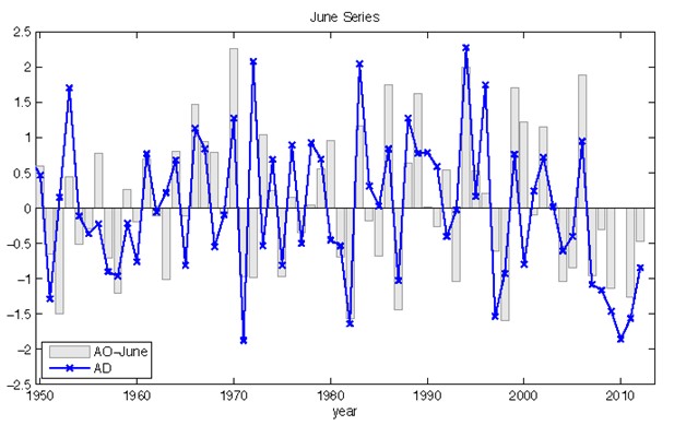
The June AD index from 1950 to 2012 shows how unusual recent years have been.
In the last 6 years we've had:
2007's loss of 1/4 of the sea ice area, and the start of an unusual assertion of the Arctic Dipole. Continued year-on-year volume loss (PIOMAS) with
2010's loss of volume equalling 2007, and the majority of the thickest, oldest ice off the Canadian Arctic Archipelago (CAA) being lost. The area record of 2007 being beaten in 2011, and that new record smashed this year. Even taking into account the AD, the weather of the last two years hasn't been as conducive to ice melt as 2007. After 2011 I was wavering in my view that we'd have late summer sea ice through until late next decade. Earlier this year I said I'd reconsider after this year, and what happened this year?
From June when the ice retreat began in earnest inside the Arctic basin, the ice was retreating abnormally rapidly. This is seen in Cryosphere Today area anomalies (my calculation - 1980 to 1999 baseline).
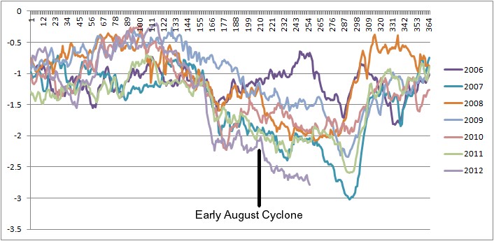
The early August cyclone did have a significant effect, but even before that anomalies from the baseline were well below even 2007, without the cyclone it was still very likely that 2007's record would be broken. The early August cyclone merely exacerbated what was already likely by the end of June, a new record was going to be set.
Following the near elimination of the oldest ice I had anticipated that the volume loss would abate. This is a reasonable expectation given that the preceding interannual trend of volume loss had been from loss of old thick multi-year ice, as shown by ICESat and PIOMAS. Against the volume loss would then be the thinner younger ice with its fast response times, more able to rebound from forcing events like 2010 and this year. The rebound of younger ice has come into play, the first graphic in this post shows that happening in the PIOMAS domain. In the real world the larger area (CT) losses of years since 2007 have been countered by larger growth, enlarging the seasonal cycle. There are two processes happening here, discrete in time and process: During the melt season (Mar - Sept) thinner ice has more readily revealed open ocean, while during the early freeze season large new areas of open ocean have vented most of the energy gained during the summer into the atmosphere leading to delayed but ultimately vigorous horizontal spread of ice, with subsequent thickening over winter, a negative feedback on the summer's ice albedo feedback driven recession. But this is not enough as the volume losses have continued. I see no negative feedbacks that are likely to come into play that aren't already active - the overall feedback is strongly positive.
I'm now pretty well convinced that we are in a Rapid Ice Loss Event (RILE), probably a doozy of a RILE. I can see two main problems with this viewpoint, the biggest one is that March 2012 shows no evidence of a further loss of volume, but I'm expecting further March volume loss this year. The second is the role of weather.
It may seem that the involvement of weather in 2007, 2010, and the AD in the post 2007 era detracts from this view point of an ongoing RILE. However Holland notes in her presentation that RILEs are driven thermodynamically with ice dynamics playing a small stabilising role. In other words, in the models RILEs aren't driven by factors like ice-albedo but are driven by atmospheric and oceanic processes causing influxes of heat into the Arctic. In the extreme AD event of 2007, the assertion of the AD thereafter, and the unusual combination of weather leading to 2010's PIOMAS volume loss, we are seeing atmospheric processes that are thermodynamically driving ice loss. The processes behind the post 2007 assertion of the AD are not yet clear, snow forcing may play a role due to earlier snow melt. But it strikes me as stretching coincidence too far to claim there is no feedback and that the AD just happened to assert itself in the wake of 2007, when ice thickness had been substantially reduced, and ice retreat during the year had stepped into a faster gear.
The volume loss of 2010 was driven by the Warm Arctic Cold Continents pattern pre-conditioning ice in the winter and a massive warm anomaly over Northern Canada. In the case of the former, Cohen has shown linkage to the state of Arctic sea ice (more here), and in the case of both factors, they would not have had the dramatic impact but for decades of pre-conditioning, as the 1981 volume loss shows.
The Arctic atmosphere, and ocean are not passive players in the changes that are afoot, and their net role is to hasten ice loss.
If I take any one aspect of my argument I can see reason for doubt, reason to delay expressing this opinion, but when I put it all together I'm battered into submission by the overall pattern of the evidence. If I delay until I'm absolutely certain I might well be calling the blog post; "Well that was a RILE!"
So if I do think we're in a RILE, what do I expect to see in the future? I anticipate a rapid transition by 2020, but it may be much earlier. Given that I don't think anyone really has a grip on what's going on I don't think anyone can say for sure how fast it will be. Simplistic hand waving about ice-albedo effect driving the process neglects the AD role I outlined in my previous posts, and tells us nothing about the interplay between ice albedo and heat loss in autumn due to open water and thinner ice. As I accept that I have no more of a grasp of this than I think anyone else does, I'm not hazarding guesses as to how exactly the whole thing will play out. It's enough to say: By 2020 possibly much sooner. Which is vague enough to cover a lot of the uncertainty, but represents a substantial shift from where I was a year ago.
However in the course of the next 12 months I do think it's possible to outline the following bullet points shaping what I expect.
- I don't expect to see a substantially delayed refreeze of the same order as 2007, that's because there's not been the sunny skies over open water seen in 2007. Once it gets started the refreeze will be fast.
- I expect a volume loss between PIOMAS maxima for March 2012 and March 2013. i.e. this year's losses will not be made up over the winter.
- I expect large positive anomalies of NCEP/NCAR temperature in the lower troposphere, biassed towards the surface, from February to April. That's not to say it will be warm, but it won't be as cold as in years before 2010.
- Piomas volume anomalies will fall throughout May - June.
- I expect large positive anomalies of NCEP/NCAR temperature in the low to mid troposphere in May and June. Again, maintaining the apparent warming since 2010.
- There will be a massive crash in Cryosphere Today area anomalies during early June. Going at least as low as 2012, probably lower.
- There will be the development of a high pressure anomaly over Greenland in June persisting through July and into August. This will form an AD anomaly in tandem with low pressure over the Siberian sector.
- CT Area at minimum in September will be lower than the 2011 record of 2.9M km^2, likely at least matching this year's record, which is 2.23M km^2. There remains the significant possibility of a further crash well below this year, I can't hazard a guess as to the magnitude of such future crashes.
21 comments:
Excellent presentation of the overwhelming evidence Chris! Additionally, I would add the prediction that it's going to be a busy year with lots of newcomers over at Neven's site!
Brian
Yeah, Neven's wife will be a sea-ice widow. ;)
I know others seem to have IDs and post blog posts there. Looks like it'll have to be a team effort!
Been lurking about at various places, wanted to say that I think you're dead on here that the main unknowable driver is essentially how the cumulative changes since 2007 have effected other atmospheric and oceanic patterns that could wind up dramatically speeding the process.
Is this AD pattern essentially driven by the loss of ice since 2007? We don't know, but it's quite possible, looking likely with the data we have so far. If it's the new summer normal, though, this thing is probably going down fast. 2007 looks to me to have been a quick shift to a new, temporary _atmospheric_ situation that will speed the rest of the system down, and all of the factors will loop into each other.
Nature has no particular loyalty to smooth curves, of course. I think we've very much failed to account for the sudden effects past some critical point of having less solid, thick ice -- particularly on weather patterns up there in the summer, which in turn effect the ice, along with how many other factors?
That's the problem here to me -- any one of the factors involved may hit what would be its own little "equilibrium" if all else were equal, but there are likely far fewer equilibrium states that can possibly hold that way for all of the relevant parts at once. Each piece of the puzzle will reach for equilibrium and each will fail fairly quickly until they all find it at the same time to satisfy the whole -- how soon will they intersect? How many dependent variables within the bigger picture have we forgotten to include, and how many can we simply not predict with any accuracy whatsoever?
We don't know any of it for sure, of course, and figuring out all of the factors that go into these patterns is something I'm very glad I get to think about broadly with some science background but without having to publish anything or try to work the data too hard. I can't imagine how one could even begin to model this well, and those who try really get a lot of crap they don't deserve, IMO, when they turn out to have been off.
Also just wanted to say kudos for shifting your views as the data available changes. I'm probably more pessimistic than you about some of the speed here generally -- or at least the potential for it -- but trying to remain open to new thoughts on the subject is so important either way.
Back to reading. But many thanks to you and all of the other folks really working on making this all an honest conversation, to the best of your ability.
My view had been that the ice was transitioning to a new pseudo-equilibrium state, one with an ice pack composed almost entirely of young ice. I now doubt that such a pseudo-equilibrium state exists...
Surely it not only doesn't exist but is a contradiction in terms? An ice pack consisting predominantly of young (first-year?) ice is by definition an ice pack that largely melts away every summer. That's, um, why it's young.
Peter,
I said 'young' not 'first year'. Maslanik's graphic from NSIDC shows decline of ice >4 years old, but more steady levels of ice <4 years old.
The question for now is not whether a FY ice pack, that ends the season with no ice, is stable - but whether a predominantly young pack is stable. I had thought we'd see a reduction in volume loss as the pack stabilised with ages typically below 4 years old. So the pack would have been semi-stable (given ongoing forcing from AGW), and could hold area/extent/volume from crashing out in late summer.
Anon,
Thanks for the comment.
Until the last decade the arctic was receiving 99,000 petajoules more heat in the summer than it could lose in the winter. See: The Melting of Arctic Ice. The ice has literally been behaving like ice cubes in tumbler of water. In recent years this excess heat has increased dramatically, perhaps doubling. I think we should be very worried.
John,
Thanks for the comment, there's a core of truth in what you say, but glasses of water don't get stratified by salinity and temperatures, and don't have the interaction between ocean and bathymetry, or atmosphere and orography.
I do agree with you (checked out your blog) that, especially with the combined risks from AGW and fossil fuel depletion, the UK is too crowded, and that we need to be closing the door to further immigration.
I'm reminded of the lifeboat analogy: You're in a packed lifeboat having rowed away from the sinking ship. The ship goes down suddenly dumping hundreds of people in the freezing sea. It may seem that the humane thing to do is to row back to try to help those in the water, but if you do that odds are you'll be sunk by the masses in the water trying to get into your boat. The only rational course of action is to row away from them. Harsh, but survival can be like that.
We need to continue international aid and development as we're doing now, last time I read up on it, it seems rather a reasonable approach is being taken by the UK government. But I think it's time to prepare for what the rest of this century will bring, and haul the ladders up now. And NO! That doesn't make me a racist. I take people as I find them regardless of creed or colour. FWIW, the best areas I've lived in previously have been Asian (Hindu/Sikh) - good peaceable neighbours and a low crime rate.
Yeah, Neven's wife will be a sea-ice widow. ;)
That's not funny! :-p
Great stuff, Chris, as always. Instead of ending, I feel like we are only getting started. Let the freeze begin!
Thanks Neven,
I think we're on the verge of some very exciting years.
Thanks for helping make this clear to us all.
Seems to me that the whole ice cap is thinning, and the >4m ice is disappearing fastest simply because it is the upper band, and not being replaced, whereas the >4m ice melts and 'becomes' 3m ice. Now that the thickest parts have nearly all been reduced to <4m, it will be the 3m ice that starts to diminish more rapidly next, and so on, until only new ice remains, forming over winter, and totally disappearing each summer, very rapidly I imagine, as the lack of thickness will make it really vulnerable to quick break up and melt.
Is there a map showing the change in thickness year on year, I'd like to see the pattern of the rate of change of thickness.
Overall it's very worrying, and although there's been a decent amount of media coverage, I haven't seen much political discussion about it. Hopefully the presidential debates in the US might bring it under the spotlight.
I'm waiting to see what this winter will bring, weather-wise, with the warnings that it'll be very 'interesting'.
Thanks again.
Jon,
The volume loss of 2010 virtually removed grid boxes reporting ice of over 3.5m thick from PIOMAS, sugesting that there is now a negligible amount of thick old ice in the Arctic basin.
See the fourth graphic down this page for a less detailed plot:
http://dosbat.blogspot.co.uk/2012/09/why-2010-piomas-volume-loss-was.html
There's also a spreadsheet with the source data linked to at the end of that post - the V2 plot is the one to use now.
That graphic I mention shows the shift you're talking about: The 2-3m and 1-2m categories increase as ice volume is 'demoted' to lower categories.
You'll find thickness difference maps here:
http://www.arctic-charts.net/volume-charts/InterAnnDiff/
Those are interannual differences, March-March and Sept-Sept, so for 2007 the maps shows 2007 thickness at each point minus 2006 thickness. Again that's from PIOMAS.
Thanks a lot Chris! Just what I was after!
Chris, I think you'll find this interesting Seafloor Control On Sea Ice by Son Nghiem. Jamie Morison has a slideshow highlighted in the NY Times on the same subject (An Arctic Expert's View of the Great Ice melt of 2012) and credits Nghiem for the idea.
Thanks again Kevin.
Yes I've read the Nghiem paper - it's why I keep saying the Atlantic Water won't play much of a role in warming. That's because AW drops off the edge of the deep in Atlantic. I see it as a key player in the lack of retreat in the Atlantic sector.
I'm less convinced about the strength of this bathymetric effect in the Siberian/Pacific Sectors because here the ice edge shows less of a tendency to be stalled at the bathymetric drop off into the abyss, you'll see that in Beaufort.
I'm not convinced about the role of the Herald canyon - I'd been expecting seperate ice regions, with one broken off from the main pack (the first instance of this on such a scale IIRC) but my reasoning was due to wind speeds implied by pressure gradient.
The AW issue is special due to the salinity of the Atlantic (denser than Arctic) and its warm temperatures. This doesn't apply to water warmed by insolation and AD driven flow through Bering - which starts off being native to the Artic. I still think insolation can cause a summer warm cap over the colder deep thus being largely immune to bathymetry. That's one peripheral reason I think we'll see a fast transition - bathymetry won't dictate a refuge region.
Chris, I thought the take-away graf was this:
"The seafloor structures can dictate where perennial sea ice resides across the Arctic Ocean: over the deep basin off the continental shelf of the Laptev Sea, the Kara Sea, and Barents Sea, and over the continental shelf of the Beaufort Sea. This distribution of perennial sea ice is coincidentally located along the primary path of the Transpolar Drift. In strong Polar Express events driven by strong wind forcing supported the atmospheric dipole anomaly (Nghiem et al., 2007), an excessive transport of perennial sea ice out of the Arctic via the Fram Strait can results in massive ice loss since perennial ice is the older and thicker type of sea ice compared to first year or seasonal sea ice. While the Polar Express is driven by anomalous winds, the direction ofthe ice transport along the Transpolar Drift is not arbitrary as it is limited in the deep transpolar basins such as the Nansen Basin, and aligned along Lomonosov Ridge across the Arctic Ocean (Alkire et al., 2007). Such bathymetry control on the location of perennial sea ice sets up a condition conducive to an abrupt reduction of perennial sea ice, which in turn preconditions the large decrease of the total SIE during summer."
The bathymetry is a double-edged sword: allowing the build-up of thicker ice, but then acting as a natural conduit for its rapid evacuation.
Kevin,
The reason I don't think that's such a significant factor any more is that the Beaufort Gyre flywheel has failed, is is no longer rotated and aged in the gyre before being dumped into the stream of the transpolar drift over the Lomonsov ridge, but is melted away most years in the Pacific sector open water.
I did a post earlier this year disagreeing with someone's claiming to be able to predict the ice edge in September. The reason I gave was that they were picking up key features of all years' minima. One of these is the ice tongue that is seen in 2010 and 2011 , see here, which is to the pacific side of the Lomonsov ridge. I think that the lack of surface melt they were seeing was due to thicker ice in that region - due to the bathymetric factor Nghiem outlines there.
I accept the tendency for the Odden ice tongue to cling to Greenland's continental shelf, and the bathymetric effects on perennial ice in Beaufort. However I still think the biggest single factor is in the Atlantic sector due to the dropping of AW out of contact with the ice as it hits the edge of the abyss (I forget the name of that abyssal deep).
Just looking at this year and 2007 shows, I think, an important lesson for future summers. Whatever recession there will be will come from the Pacific sector, not the Atlantic.
Actually this Nghiem paper isn't the reason for my thoughts about the Atlantic sector - I find I only downloaded it earlier this summer. I've tied the Atlantic sector lack of recession to bathymetry for longer than that - puzzled.
BTW, I see you're having fun over at Nevens. ;)
I must admit to being dumbfounded by someone that thinks weather forecasting is a science - and climate science is alchemy. He apparently doesn't realize that they are virtually one and the same. The difference of course being that short-range model output (weather) is obviously going to be more accurate than long-range model output (climate).
Some people must think there's a team of meteorologists at ECMWF (for instance) that sit around each day looking at maps, radar images, perusing terabytes of observations and then decide what to put into their weather forecasts.
I've given up with that individual. I struggle to see the difference from the denialists.
Chris, there's a lengthy paper available for reading and comment at Ocean Science Discussions - Arctic rapid sea ice loss events in regional coupled climate scenario experiments by
R. Doscher and T. Koenigk.
They examine 30 different RILEs found in their model runs and classify, compare, and contrast the processes behind them. I think you'll find corroboration for many of your insights. From the concluding summary:
The mechanisms for rapid ice loss we find here are predominantly related to atmospheric circulation and seasonal-to interannual memory build up in the ice thickness. We also tested the idea of possible upward transport of ocean heat by vertical mixing in response to reduced ice concentration. Such a process was not found in this model although observations indicate import of warm ocean water from the Pacific
Ocean (Woodgate, 2010) and proximate inclusion in vertical mixing. While those observed results are under discussion, we cannot expect to find them in the model due to to coarse resolution and insufficient Bering Strait inflow.
Kevin,
Right, I've just read it, didn't mean to. I just started and carried on to the end.
It's hard going, there's a lot of detail there. With regards the AD it's possible that as Overland 2012 notes the GCM isn't picking up the factors driving the summer AD.
However in any case, the paper states: "The SLP anomaly during the summer event is given by an elongated high pressure ridge over the European and Eurasian coast, connected to an anomalous inflow of warm air from the Nordic Seas into the Arctic ocean."
That's not the summer configuration post 2007!
The comment regarding BC amused me - that always seemed a rather minor issue. The albedo changes due to younger ice seem to wipe that issue off the table in terms of significance.
Thanks for that paper. I clearly need to read it again when I'm not so tired.
If you want to write posts for this blog you're welcome - you've got my email. But I can't help but wonder - why not start your own blog? IMO it's important to have as many blogs out there as possible to counter the denialist nutters.
Post a Comment